Nihommatsu monthly weather averages
Average daytime temperature
The bar chart below shows the average monthly peak daytime temperatures at Nihommatsu
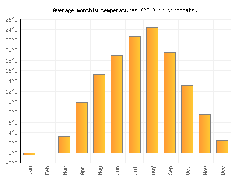
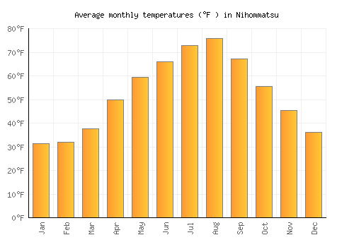
| Jan | Feb | Mar | Apr | May | Jun | Jul | Aug | Sep | Oct | Nov | Dec | |
|---|---|---|---|---|---|---|---|---|---|---|---|---|
| °C | 3.3 | 3.8 | 7.6 | 15.2 | 20.5 | 23.1 | 26.6 | 28.5 | 23.4 | 17.6 | 12 | 6.4 |
| °F | 38 | 38.9 | 45.6 | 59.3 | 69 | 73.6 | 79.8 | 83.4 | 74.1 | 63.7 | 53.6 | 43.5 |
Please note: these are the average peak daytime temperatures (usually around mid-afternoon) so do not show daytime / night highs and lows. To see the daily range of temperatures have a look at the temperature max / min chart below.
Average rainfall & rainy days
The graph below shows the average rainfall and number of rainy days per month.
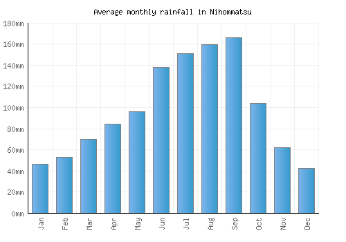
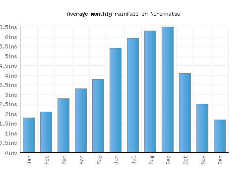
| Jan | Feb | Mar | Apr | May | Jun | Jul | Aug | Sep | Oct | Nov | Dec | |
|---|---|---|---|---|---|---|---|---|---|---|---|---|
| mm | 46 | 53 | 70 | 84 | 96 | 138 | 151 | 159 | 166 | 104 | 62 | 43 |
| inches | 1.8 | 2.1 | 2.8 | 3.3 | 3.8 | 5.4 | 5.9 | 6.3 | 6.5 | 4.1 | 2.5 | 1.7 |
| Rainy days | 26 | 23 | 22 | 17 | 17 | 20 | 21 | 19 | 20 | 18 | 19 | 23 |
Average annual rainfall in Nihommatsu: 1350.9mm (531.9 inches)
Average daily sunshine
The bar chart below shows the average daily sunshine hours in Nihommatsu
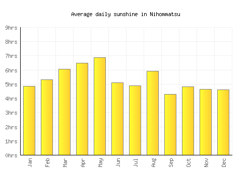
| Jan | Feb | Mar | Apr | May | Jun | Jul | Aug | Sep | Oct | Nov | Dec | |
|---|---|---|---|---|---|---|---|---|---|---|---|---|
| Hrs sunshine | 4.8 | 5.3 | 6 | 6.5 | 6.9 | 5.1 | 4.9 | 5.9 | 4.3 | 4.8 | 4.7 | 4.6 |
Day / night temperatures
The graph below shows the daily range of temperatures for each month.
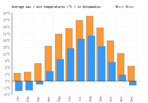
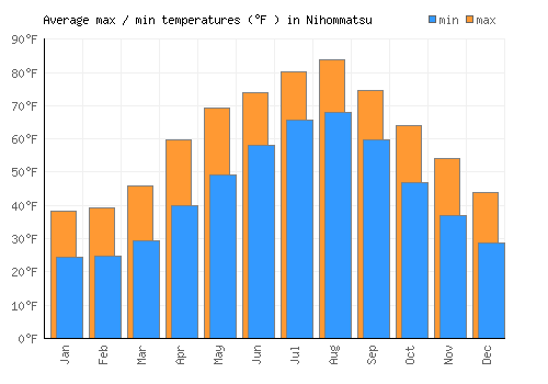
| Jan | Feb | Mar | Apr | May | Jun | Jul | Aug | Sep | Oct | Nov | Dec | |
|---|---|---|---|---|---|---|---|---|---|---|---|---|
| Min °C | -4.3 | -4 | -1.4 | 4.4 | 9.6 | 14.5 | 18.7 | 20.1 | 15.4 | 8.4 | 2.8 | -1.8 |
| Max °C | 3.5 | 4 | 7.8 | 15.5 | 20.8 | 23.3 | 26.8 | 28.8 | 23.6 | 17.9 | 12.3 | 6.6 |
| Min °F | 24.3 | 24.8 | 29.5 | 39.8 | 49.3 | 58.1 | 65.6 | 68.1 | 59.7 | 47 | 37 | 28.8 |
| Max °F | 31.3 | 32 | 37.8 | 49.8 | 59.4 | 66 | 72.9 | 75.9 | 67.1 | 55.6 | 45.5 | 36.3 |
Sea temperature
The graph below shows the average sea temperature.
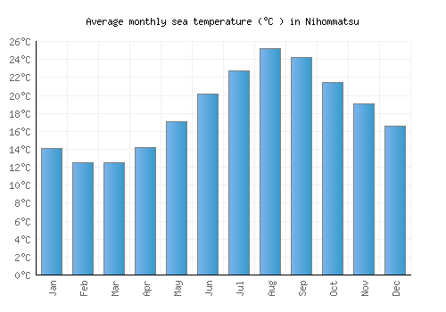
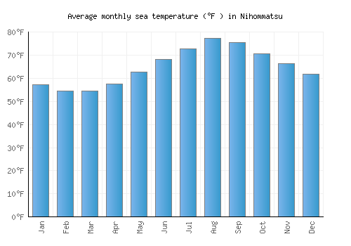
| Jan | Feb | Mar | Apr | May | Jun | Jul | Aug | Sep | Oct | Nov | Dec | |
|---|---|---|---|---|---|---|---|---|---|---|---|---|
| °C | 14.1 | 12.5 | 12.5 | 14.2 | 17.1 | 20.1 | 22.7 | 25.2 | 24.2 | 21.5 | 19.1 | 16.6 |
| °F | 57.3 | 54.5 | 54.5 | 57.5 | 62.7 | 68.3 | 72.9 | 77.4 | 75.6 | 70.7 | 66.3 | 61.8 |
Wind speed
The graph below shows the average wind speed.
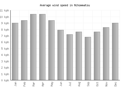
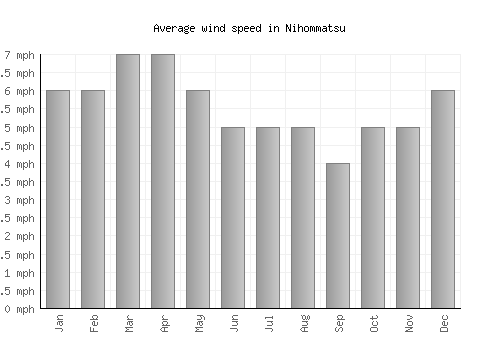
| Jan | Feb | Mar | Apr | May | Jun | Jul | Aug | Sep | Oct | Nov | Dec | |
|---|---|---|---|---|---|---|---|---|---|---|---|---|
| km/h | 9 | 9 | 10 | 10 | 9 | 8 | 7 | 8 | 7 | 8 | 8 | 9 |
| mph | 6 | 6 | 7 | 7 | 6 | 5 | 5 | 5 | 4 | 5 | 5 | 6 |
A monthly average windspeed of over 16km/h or 10mph suggests a location is fairly windy.
Relative humidity
The graph below shows the average relative humidity.
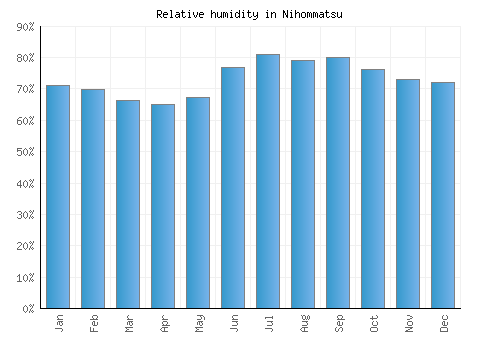
| Jan | Feb | Mar | Apr | May | Jun | Jul | Aug | Sep | Oct | Nov | Dec |
|---|---|---|---|---|---|---|---|---|---|---|---|
| 71% | 70% | 66% | 65% | 67% | 77% | 81% | 79% | 80% | 76% | 73% | 72% |
Other monthly averages
Nihommatsu weather stats
| Hottest month: | August | 28.5°C 83.3°F |
|---|---|---|
| Driest month: | December | 43mm 1.7ins |
| Sunniest month: | March | 6hrs |
| Coldest month: | January | 3.3°C 37.9°F |
| Wettest month: | September | 166mm 6.5ins |
| Warmest sea: | August | 25.2°C 77.4°F |

Locations nearby
Top Japan locations
- Fukuoka
- Hakodate
- Hakone
- Hiroshima
- Kagoshima
- Kamakura
- Kanazawa
- Kōbe
- Kyoto
- Nagoya
- Naha
- Nara
- Nikkō
- Ōsaka
- Sapporo
- Sendai
- Takayama
- Tokyo
- Yokohama